
Mapa topográfico Anshan City
Mapa interativo
Clique no mapa para exibir a altitude.
Anshan City
Local transportation is primarily by bus or taxi. Anshan used to have a single tram line—along Zhonghua Avenue, through the city centre and past Angang main gate—but this has been closed and the tracks removed. Due to the flat topography of the city centre, bicycles are popular. Almost all roads have a wide cycle lane on each side. Often this lane is further protected by a traffic island that separates the bikes from larger motor vehicles.
Sobre este mapa
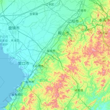
Nome: Mapa topográfico Anshan City, altitude, relevo.
Local: Anshan City, Liaoning, China (39.99865 122.18702 41.56818 123.76188)
Altitude média: 145 m
Altitude mínima: -2 m
Altitude máxima: 1.111 m
Outros mapas topográficos
Clique em um mapa para visualizar sua topografia, sua altitude e seu relevo.
Anshan
Local transportation is primarily by bus or taxi. Anshan used to have a single tram line—along Zhonghua Avenue, through the city centre and past Angang main gate—but this has been closed and the tracks removed. Due to the flat topography of the city centre, bicycles are popular. Almost all roads have a…
Altitude média: 79 m