
Faça uma doação
Mapa topográfico Florence
Clique no mapa para exibir a altitude.
Faça uma doação
Florence
Florence is located in the coastal plain of South Carolina. It is in the northeastern part of the state and the northern part of Florence County. The average elevation above sea level is around 140 ft (43 m). Jeffries Creek is a tributary of the Great Pee Dee River and is the main waterway that flows through the city, passing south of the city center. According to the United States Census Bureau, the city has a total area of 23.49 square miles (60.8 km2), of which 23.39 square miles (60.6 km2) is land and 0.09 square miles (0.23 km2) (0.38%) is water.
Faça uma doação
Sobre este mapa
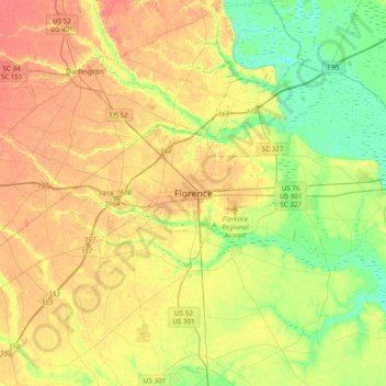
Nome: Mapa topográfico Florence, altitude, relevo.
Altitude média: 35 m
Altitude mínima: 9 m
Altitude máxima: 62 m
Faça uma doação
Outros mapas topográficos
Clique em um mapa para visualizar sua topografia, sua altitude e seu relevo.
Florence
United States > South Carolina > Florence County
Florence is located in the coastal plain of South Carolina. It is in the northeastern part of the state and the northern part of Florence County. The average elevation above sea level is around 140 ft (43 m). Jeffries Creek is a tributary of the Great Pee Dee River and is the main waterway that flows through…
Altitude média: 37 m
Florence Soccer Complex
United States > South Carolina > Florence County > Florence
Altitude média: 42 m
Faça uma doação
Florence
United States > South Carolina > Florence County
Florence is located in the coastal plain of South Carolina. It is in the northeastern part of the state and the northern part of Florence County. The average elevation above sea level is around 140 ft (43 m). Jeffries Creek is a tributary of the Great Pee Dee River and is the main waterway that flows through…
Altitude média: 37 m