
Mapa topográfico Vysoké Tatry
Mapa interativo
Clique no mapa para exibir a altitude.
Sobre este mapa
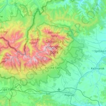
Nome: Mapa topográfico Vysoké Tatry, altitude, relevo.
Local: Vysoké Tatry, District of Poprad, Region of Prešov, Slovakia (49.08034 19.88393 49.28609 20.38501)
Altitude média: 1.024 m
Altitude mínima: 568 m
Altitude máxima: 2.593 m
The town of Vysoké Tatry is special in many aspects. It is not a true town, but a conglomerate of separate and different settlements (originally separate villages), whose only common feature is that they are the main tourist resorts in the Slovak High Tatras, while being connected through a common railway network (the Tatra Railway). After the country's capital, the town is Slovakia's major tourist destination. It has around 4,000 inhabitants, excluding tourists. It is located at an elevation of 1,010 m (3,310 ft) above sea level. Covering 360.22 square kilometres (139.1 square miles), it is Slovakia's second-largest urban area, after the country's capital, and was the largest until 2007, when the village of Štrbské Pleso became a part of Štrba after Štrba's municipal government's successful claim on the Supreme Court.
Outros mapas topográficos
Clique em um mapa para visualizar sua topografia, sua altitude e seu relevo.
Tatranská Lomnica
Slovakia > Region of Prešov > District of Poprad > Vysoké Tatry
Tatranská Lomnica, Vysoké Tatry, District of Poprad, Region of Prešov, Eastern Slovakia, 059 60, Slovakia
Altitude média: 915 m
Vysoké Tatry - Starý Smokovec
Slovakia > Region of Prešov > District of Poprad > Vysoké Tatry
Vysoké Tatry - Starý Smokovec, Starý Smokovec, Vysoké Tatry, District of Poprad, Region of Prešov, Eastern Slovakia, 062 01, Slovakia
Altitude média: 1.069 m
Czerwone Wierchy / Červené vrchy
Slovakia > Region of Prešov > District of Poprad > Vysoké Tatry
Czerwone Wierchy / Červené vrchy, Štrbské Pleso, Vysoké Tatry, District of Poprad, Region of Prešov, Eastern Slovakia, Slovakia
Altitude média: 1.730 m
Vysoké Tatry - Tatranské Matliare
Slovakia > Region of Prešov > District of Poprad > Vysoké Tatry
Vysoké Tatry - Tatranské Matliare, Tatranská Lomnica, Vysoké Tatry, District of Poprad, Region of Prešov, Eastern Slovakia, 059 60, Slovakia
Altitude média: 900 m
Štrba
Slovakia > Region of Prešov > District of Poprad
Štrba, District of Poprad, Region of Prešov, Eastern Slovakia, Slovakia
Altitude média: 1.134 m
Tatra Mountains
Slovakia > Region of Prešov > District of Poprad
Tatra Mountains, District of Poprad, Region of Prešov, Eastern Slovakia, Slovakia
Altitude média: 922 m
Poprad
Slovakia > Region of Prešov > District of Poprad > Poprad > Poprad
Poprad, District of Poprad, Region of Prešov, Eastern Slovakia, 05851, Slovakia
Altitude média: 699 m
Rysy
Slovakia > Region of Prešov > District of Poprad > Vysoké Tatry
Rysy, Vysoké Tatry, District of Poprad, Region of Prešov, Eastern Slovakia, Slovakia
Altitude média: 2.005 m
Poprad
Slovakia > Region of Prešov > District of Poprad
Poprad, District of Poprad, Region of Prešov, Slovakia
Altitude média: 709 m