
Obrigado por apoiar este site ❤️
Faça uma doação
Faça uma doação
Mapa topográfico Adina
Clique no mapa para exibir a altitude.
Obrigado por apoiar este site ❤️
Faça uma doação
Faça uma doação
Adina
Adina is a town and union council of Swabi District in Khyber Pakhtunkhwa. It is located at an altitude of 303 metres (997 feet).
Obrigado por apoiar este site ❤️
Faça uma doação
Faça uma doação
Sobre este mapa
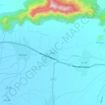
Nome: Mapa topográfico Adina, altitude, relevo.
Altitude média: 378 m
Altitude mínima: 308 m
Altitude máxima: 1.017 m
Obrigado por apoiar este site ❤️
Faça uma doação
Faça uma doação
Outros mapas topográficos
Clique em um mapa para visualizar sua topografia, sua altitude e seu relevo.
Indus
Pakistan > Khyber Pakhtunkhwa > Swabi District > Allāhdher
In the uppermost, highest part of the Indus River basin there are relatively few genera and species: Diptychus, Ptychobarbus, Schizopyge, Schizopygopsis and Schizothorax snowtrout, Triplophysa loaches, and the catfish Glyptosternon reticulatum. Going downstream these are soon joined by the golden mahseer Tor…
Altitude média: 281 m