
Mapa topográfico Vișeu de Sus
Mapa interativo
Clique no mapa para exibir a altitude.
Sobre este mapa
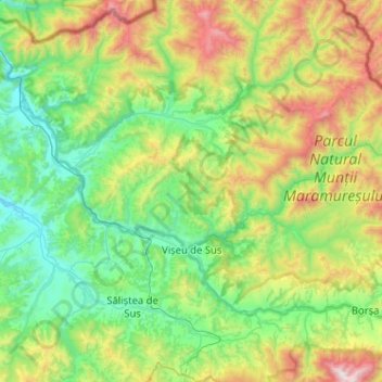
Nome: Mapa topográfico Vișeu de Sus, altitude, relevo.
Local: Vișeu de Sus, Maramureș, Romania (47.65891 24.37557 47.86529 24.88777)
Altitude média: 865 m
Altitude mínima: 348 m
Altitude máxima: 2.266 m
Vișeu de Sus is located in the northeastern part of Maramureș County, on the border with Ukraine. The town lies at the confluence of the rivers Vișeu and Vaser, at an altitude of 427 m (1,401 ft) above sea level, having the characteristics of a mountain city. It neighbors the communes of Moisei to the southeast, Vișeu de Jos to the west, and Poienile de sub Munte to the northwest. It also borders Maramureș Mountains Natural Park to the north, and Rodna Mountains National Park to the south-east. The town administers a surface area of 44,306 ha (109,480 acres), making it the second-largest town by area in Romania.
Outros mapas topográficos
Clique em um mapa para visualizar sua topografia, sua altitude e seu relevo.
Băile Borșa
Băile Borșa, Borșa, Maramureș, 435250, Romania
Altitude média: 917 m
Chiuzbaia
Romania > Maramureș > Baia Sprie > Chiuzbaia
Chiuzbaia, Baia Sprie, Maramureș, 435101, Romania
Altitude média: 635 m
Sighetu Marmatiei
Romania > Maramureș > Sighetu Marmatiei
Sighetu Marmatiei, Sighetu Marmației, Maramureș, 435500, Romania
Altitude média: 312 m