
Obrigado por apoiar este site ❤️
Faça uma doação
Faça uma doação
Mapa topográfico Schärding
Clique no mapa para exibir a altitude.
Obrigado por apoiar este site ❤️
Faça uma doação
Faça uma doação
Schärding
The town sits at an altitude of 313 meters and is located in the Innviertel. It measures 4.1 kilometers from north to south, 1.9 km from west to east. The total area is 4.08 km². 2.4 percent of the area is forested, 31.7 percent is used for agriculture.
Obrigado por apoiar este site ❤️
Faça uma doação
Faça uma doação
Sobre este mapa
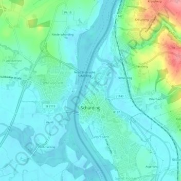
Nome: Mapa topográfico Schärding, altitude, relevo.
Local: Schärding, Bezirk Schärding, Upper Austria, 4780, Austria (48.44212 13.42690 48.47889 13.45229)
Altitude média: 323 m
Altitude mínima: 301 m
Altitude máxima: 410 m
Obrigado por apoiar este site ❤️
Faça uma doação
Faça uma doação
Outros mapas topográficos
Clique em um mapa para visualizar sua topografia, sua altitude e seu relevo.