
Faça uma doação
Mapa topográfico Alta Sierra
Clique no mapa para exibir a altitude.
Faça uma doação
Alta Sierra
Alta Sierra was laid out by property developers in the 1960s. Alta Sierra is a golf course community, with homes built around the Alta Sierra Country Club, a semi-private 18 hole course built in 1964. The community has a member-owned airport with a 2800 foot runway. The community is located just east of California State Highway 49, at an elevation of approximately 2300 feet, between the cities of Grass Valley, California to the north and Auburn, California to the south. There is a small commercial district with several restaurants, a gas station, a market and personal service businesses. There is also an elementary school and a motel.
Faça uma doação
Sobre este mapa
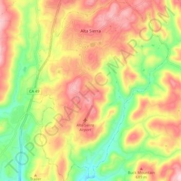
Nome: Mapa topográfico Alta Sierra, altitude, relevo.
Local: Alta Sierra, Nevada County, California, United States (39.08918 -121.08055 39.15229 -121.01878)
Altitude média: 603 m
Altitude mínima: 449 m
Altitude máxima: 747 m
Faça uma doação