
Obrigado por apoiar este site ❤️
Faça uma doação
Faça uma doação
Mapa topográfico Thrissur
Clique no mapa para exibir a altitude.
Obrigado por apoiar este site ❤️
Faça uma doação
Faça uma doação
Thrissur
Thrissur is the headquarters of Thrissur district, in the centre of the Indian state of Kerala. The city is 75 km north-east of Kochi, 133 km south-west of Coimbatore, 124 km south-east of Kozhikode and 151 km north of Changanacherry. The city is located in a hillock called Thekkinkadu Maidan which is the second highest point in city after the Vilangan Hills. The city has an average altitude of 2.83 metres above sea level.
Obrigado por apoiar este site ❤️
Faça uma doação
Faça uma doação
Sobre este mapa
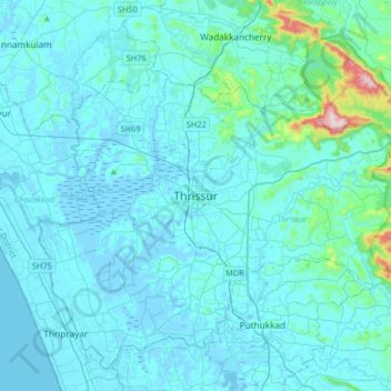
Nome: Mapa topográfico Thrissur, altitude, relevo.
Local: Thrissur, Kerala, 680001, India (10.36701 76.05462 10.68701 76.37462)
Altitude média: 36 m
Altitude mínima: -6 m
Altitude máxima: 516 m
Obrigado por apoiar este site ❤️
Faça uma doação
Faça uma doação
Outros mapas topográficos
Clique em um mapa para visualizar sua topografia, sua altitude e seu relevo.