
Obrigado por apoiar este site ❤️
Faça uma doação
Faça uma doação
Mapa topográfico Rockcliffe
Clique no mapa para exibir a altitude.
Obrigado por apoiar este site ❤️
Faça uma doação
Faça uma doação
Sobre este mapa
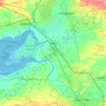
Nome: Mapa topográfico Rockcliffe, altitude, relevo.
Local: Rockcliffe, Cumberland, England, United Kingdom (54.92772 -3.18281 54.98593 -2.93883)
Altitude média: 20 m
Altitude mínima: -2 m
Altitude máxima: 80 m
Obrigado por apoiar este site ❤️
Faça uma doação
Faça uma doação
Outros mapas topográficos
Clique em um mapa para visualizar sua topografia, sua altitude e seu relevo.
Scafell Pike
United Kingdom > England > Cumberland
Scafell Pike (/ˈskɔːfɛl paɪk/) is a mountain in the Lake District region of Cumbria, England. It has an elevation of 978 metres (3,209 ft) above sea level, making it the highest and the most prominent mountain in England. The mountain is part of the Scafell massif, an extinct volcano, and is one of the…
Altitude média: 679 m
Obrigado por apoiar este site ❤️
Faça uma doação
Faça uma doação