
Mapa topográfico Gershasen
Mapa interativo
Clique no mapa para exibir a altitude.
Sobre este mapa
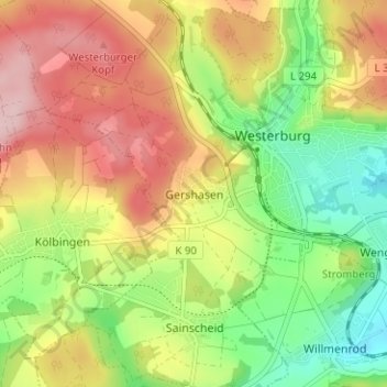
Nome: Mapa topográfico Gershasen, altitude, relevo.
Altitude média: 396 m
Altitude mínima: 299 m
Altitude máxima: 501 m
Outros mapas topográficos
Clique em um mapa para visualizar sua topografia, sua altitude e seu relevo.
Sainscheid
Deutschland > Rheinland-Pfalz > Westerwaldkreis > Westerburg
Sainscheid, Westerburg, Westerwaldkreis, Rheinland-Pfalz, 56457, Deutschland
Altitude média: 379 m