
Mapa topográfico Orientale
Mapa interativo
Clique no mapa para exibir a altitude.
Sobre este mapa
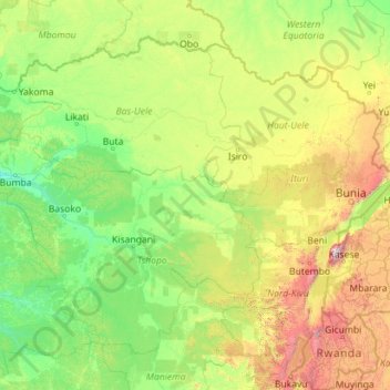
Nome: Mapa topográfico Orientale, altitude, relevo.
Local: Orientale, Democratic Republic of the Congo (-1.98102 22.26073 5.39200 31.30568)
Altitude média: 729 m
Altitude mínima: 344 m
Altitude máxima: 4.618 m
Outros mapas topográficos
Clique em um mapa para visualizar sua topografia, sua altitude e seu relevo.
Khartoum
Democratic Republic of the Congo > Kinshasa
Khartoum, Ngiri-Ngiri, Kinshasa, Democratic Republic of the Congo
Altitude média: 297 m
Terrain
Democratic Republic of the Congo > North Kivu > Beni
Terrain, Beni, North Kivu, Democratic Republic of the Congo
Altitude média: 1.084 m
Kasai-Oriental
Democratic Republic of the Congo
Kasai-Oriental, Democratic Republic of the Congo
Altitude média: 713 m
Katanga
Democratic Republic of the Congo
Katanga, Democratic Republic of the Congo
Altitude média: 1.008 m
Bandundu
Democratic Republic of the Congo
Bandundu, Democratic Republic of the Congo
Altitude média: 555 m
Mont Amba
Democratic Republic of the Congo > Kinshasa > Mbanza Lemba
Mont Amba, Mbanza Lemba, Lemba, Kinshasa, Democratic Republic of the Congo
Altitude média: 404 m
Kinshasa
Democratic Republic of the Congo > Kinshasa
Kinshasa, Aketi, Kinshasa, Democratic Republic of the Congo
Altitude média: 316 m
Mont Amba
Democratic Republic of the Congo > Kinshasa
Mont Amba, Kinshasa, Democratic Republic of the Congo
Altitude média: 359 m
Lower Uele
Democratic Republic of the Congo > Lower Uele
Lower Uele, Democratic Republic of the Congo
Altitude média: 552 m