
Faça uma doação
Mapa topográfico Meyrueis
Clique no mapa para exibir a altitude.
Faça uma doação
Meyrueis
The town of Meyrueis is located between the foothills of Mont Aigoual to the south and the Causse Méjean to the north. The town thus marks the border between the geographic areas of the Grands Causses, Causse Noir and Causse Méjean, and the Cévennes Mountains. Three rivers meet there: the Jonte, the Béthuzon and the Brèze. The communal territory extends across 10,468 hectares, delimited by an approximate rectangle 25 km long and 10 km wide. It has an average altitude of 706 metres; the highest point is 1562 metres.
Faça uma doação
Sobre este mapa
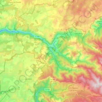
Nome: Mapa topográfico Meyrueis, altitude, relevo.
Altitude média: 993 m
Altitude mínima: 591 m
Altitude máxima: 1.483 m
Faça uma doação
Outros mapas topográficos
Clique em um mapa para visualizar sua topografia, sua altitude e seu relevo.