
Faça uma doação
Mapa topográfico Telfes im Stubai
Clique no mapa para exibir a altitude.
Faça uma doação
Telfes im Stubai
The village of Telfes is located in the front Stubaital, on the sunny left side of the Ruetz river. The municipality lies at an altitude of about 1000 m and has an area of 27.38 square kilometers. The hamlets Gerstbichl, Falschmair, Luimes, the scattered houses Telfer Wiesen and the single vineyards Wiesenhof and Gallhof (already above Schönberg) out of the valley belong to the municipality, as well as the Pfarrachalm at the Nederjoch, and the well-known hiking and skiing area Schlick below the Kalkkögel with the alpine inns Schlick (Schlickeralm) and Zirmach at the bottom of the valley, as well as Froneben and Sennjoch at the ridge (at Kreuzjoch only the cable car station).
Faça uma doação
Sobre este mapa
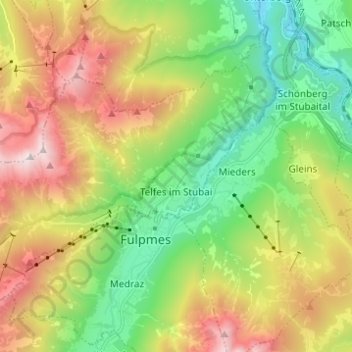
Nome: Mapa topográfico Telfes im Stubai, altitude, relevo.
Local: Telfes im Stubai, Bezirk Innsbruck-Land, Tyrol, 6165, Austria (47.13342 11.27301 47.20278 11.39599)
Altitude média: 1.430 m
Altitude mínima: 674 m
Altitude máxima: 2.591 m
Faça uma doação
Outros mapas topográficos
Clique em um mapa para visualizar sua topografia, sua altitude e seu relevo.
Hoher Burgstall
Austria > Tyrol > Bezirk Innsbruck-Land > Neustift im Stubaital
Altitude média: 2.142 m
Faça uma doação
Faça uma doação
Faça uma doação
Faça uma doação
Axamer Lizum
Austria > Tyrol > Bezirk Innsbruck-Land > Gemeinde Axams > Axamer Lizum
Altitude média: 1.858 m
Faça uma doação