
Obrigado por apoiar este site ❤️
Faça uma doação
Faça uma doação
Mapa topográfico Hillsdale
Clique no mapa para exibir a altitude.
Obrigado por apoiar este site ❤️
Faça uma doação
Faça uma doação
Sobre este mapa
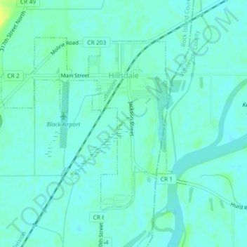
Nome: Mapa topográfico Hillsdale, altitude, relevo.
Local: Hillsdale, Rock Island County, Illinois, United States (41.59886 -90.19081 41.61776 -90.16578)
Altitude média: 178 m
Altitude mínima: 173 m
Altitude máxima: 192 m
Obrigado por apoiar este site ❤️
Faça uma doação
Faça uma doação
Outros mapas topográficos
Clique em um mapa para visualizar sua topografia, sua altitude e seu relevo.
Moline
United States > Illinois > Rock Island County > Moline
Moline witnessed a continued population increase after World War II with the completion of "Molette", a subdivision of mass-produced starter homes selling for $5,000 each. Molette was the first Moline neighborhood produced on a mass scale and one of the largest single-unit housing projects in the Midwest at…
Altitude média: 210 m