
Mapa topográfico Swansea
Mapa interativo
Clique no mapa para exibir a altitude.
Swansea
Much of Swansea is hilly with the main area of upland being located in the council ward of Mawr. Areas up to 185 metres (607 ft) in elevation range across the central section: Kilvey Hill, Townhill and Llwynmawr separate the centre of Swansea from its northern suburbs. Cefn Bryn, a ridge of high land, is the backbone of the Gower Peninsula. Rhossili Down, Hardings Down and Llanmadoc Hill are up to 193 metres (633 ft) high. The highest point is located Penlle'r Castell at 374 metres (1,227 ft) on the northern border with Carmarthenshire.
Sobre este mapa
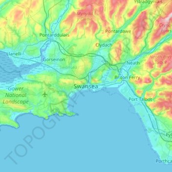
Nome: Mapa topográfico Swansea, altitude, relevo.
Local: Swansea, Wales, SA1 3BN, United Kingdom (51.45960 -4.10592 51.77960 -3.78592)
Altitude média: 73 m
Altitude mínima: -2 m
Altitude máxima: 464 m
Outros mapas topográficos
Clique em um mapa para visualizar sua topografia, sua altitude e seu relevo.