
Faça uma doação
Mapa topográfico Fruitland
Clique no mapa para exibir a altitude.
Faça uma doação
Sobre este mapa
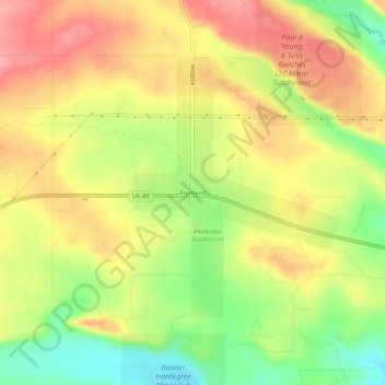
Nome: Mapa topográfico Fruitland, altitude, relevo.
Local: Fruitland, Duchesne County, Utah, 84027, United States (40.19273 -110.85961 40.23273 -110.81961)
Altitude média: 2.028 m
Altitude mínima: 1.971 m
Altitude máxima: 2.075 m
Faça uma doação
Outros mapas topográficos
Clique em um mapa para visualizar sua topografia, sua altitude e seu relevo.
Roosevelt
United States > Utah > Duchesne County
Roosevelt is situated on U.S. Route 40 in the northeast corner of the state, south of the Uinta Mountains, at an elevation of 5,250 feet (1,600 m). The town was incorporated at a mass meeting of 44 citizens on 21 February 1913. From 1906 to 1914 Roosevelt was in Wasatch County, but in 1914 Duchesne County was…
Altitude média: 1.553 m
Faça uma doação