
Mapa topográfico Chew Valley Lake
Mapa interativo
Clique no mapa para exibir a altitude.
Sobre este mapa
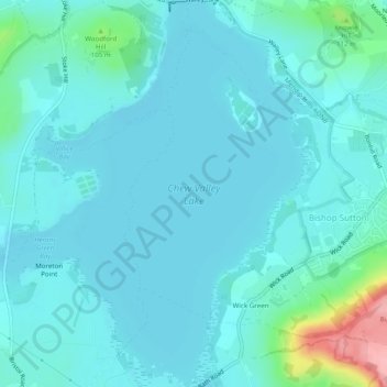
Nome: Mapa topográfico Chew Valley Lake, altitude, relevo.
Altitude média: 67 m
Altitude mínima: 50 m
Altitude máxima: 175 m
Outros mapas topográficos
Clique em um mapa para visualizar sua topografia, sua altitude e seu relevo.
River Chew
United Kingdom > England > Wick Green
River Chew, Bath Road, West Harptree, Wick Green, Bath and North East Somerset, South West England, England, BS40 6HB, United Kingdom
Altitude média: 77 m