
Mapa topográfico Timberland
Mapa interativo
Clique no mapa para exibir a altitude.
Sobre este mapa
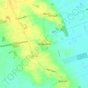
Nome: Mapa topográfico Timberland, altitude, relevo.
Altitude média: 10 m
Altitude mínima: 0 m
Altitude máxima: 22 m
Outros mapas topográficos
Clique em um mapa para visualizar sua topografia, sua altitude e seu relevo.
Wasps Nest
United Kingdom > England > Lincolnshire > North Kesteven
Wasps Nest, Nocton, North Kesteven, Lincolnshire, England, LN4 2AY, United Kingdom
Altitude média: 8 m
Digby
United Kingdom > England > Lincolnshire > North Kesteven > Digby
Digby, North Kesteven, Lincolnshire, East Midlands, England, LN4 3YJ, United Kingdom
Altitude média: 17 m
Star Fen
United Kingdom > England > Lincolnshire > North Kesteven
Star Fen, Star Fen Farm, Heckington, North Kesteven, Lincolnshire, East Midlands, England, NG34 9ND, United Kingdom
Altitude média: 4 m
Somerton Castle
United Kingdom > England > Lincolnshire > North Kesteven
Somerton Castle, Boothby Graffoe, North Kesteven, Lincolnshire, East Midlands, England, LN5 0LL, United Kingdom
Altitude média: 13 m