
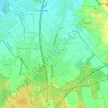
Mapa topográfico Recherswil
Mapa interativo
Clique no mapa para exibir a altitude.
Sobre este mapa
Nome: Mapa topográfico Recherswil, altitude, relevo.
Altitude média: 463 m
Altitude mínima: 450 m
Altitude máxima: 481 m
Outros mapas topográficos
Clique em um mapa para visualizar sua topografia, sua altitude e seu relevo.
Lohn-Ammannsegg
Schweiz > Solothurn > Amtei Bucheggberg-Wasseramt
Lohn-Ammannsegg, Bezirk Wasseramt, Amtei Bucheggberg-Wasseramt, Solothurn, 4573, Schweiz
Altitude média: 507 m
Lüsslingen-Nennigkofen
Schweiz > Solothurn > Amtei Bucheggberg-Wasseramt
Lüsslingen-Nennigkofen, Bezirk Bucheggberg, Amtei Bucheggberg-Wasseramt, Solothurn, 4574, Schweiz
Altitude média: 471 m
Buchegg
Schweiz > Solothurn > Amtei Bucheggberg-Wasseramt
Buchegg, Bezirk Bucheggberg, Amtei Bucheggberg-Wasseramt, Solothurn, 4586, Schweiz
Altitude média: 534 m