
Faça uma doação
Mapa topográfico Constitutional Province of Callao
Clique no mapa para exibir a altitude.
Faça uma doação
Sobre este mapa
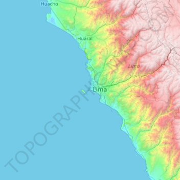
Nome: Mapa topográfico Constitutional Province of Callao, altitude, relevo.
Local: Constitutional Province of Callao, Peru (-13.06667 -78.15000 -11.06667 -76.15000)
Altitude média: 1.009 m
Altitude mínima: -3 m
Altitude máxima: 5.388 m
Faça uma doação
Outros mapas topográficos
Clique em um mapa para visualizar sua topografia, sua altitude e seu relevo.
Faça uma doação
Faça uma doação
Faça uma doação
Faça uma doação
Lake Titicaca (Peruvian sector)
Lake Titicaca has a surface elevation of 3,812 m (12,507 ft). The "highest lake" claim is generally considered to refer to commercial craft. Numerous smaller lakes around the world are at higher elevations. For many years, the largest vessel afloat on the lake was the 2,200-ton (2,425 U.S. tons), 79 m (259 ft)…
Altitude média: 4.012 m
Cajamarca
Cajamarca (Spanish pronunciation: [kaxaˈmaɾka]; Quechua: Kashamarka; Aymara: Qajamarka) is a department and region in Peru. The capital is the city of Cajamarca. It is located in the north part of the country and shares a border with Ecuador. The city has an elevation of 2,700 metres (8,900 ft) above sea…
Altitude média: 1.456 m
Faça uma doação
Faça uma doação
Arequipa
This department has a rough topography, which is characterised by heavy layers of volcanic lava covering large areas of its inter-Andean sector. It has deep canyons such as the ones formed by the Ocoña and Majes rivers. Plateaus range in height from medium, such as La Joya, and high-altitude ones such the…
Altitude média: 2.599 m
Faça uma doação
Faça uma doação
Faça uma doação