
Faça uma doação
Mapa topográfico Ball Ground
Clique no mapa para exibir a altitude.
Faça uma doação
Ball Ground
According to the United States Census Bureau as of 2020, Ball Ground has a total area of 6.3 sq mi (16 km2), of which 0.04 sq mi (0.10 km2), or 0.63%, is water. The city's elevation averages around 1,100 ft (340 m) above sea level, ranging from just over 1,000 ft (300 m) in the valleys to around 1,200 ft (370 m) on several hilltops within the city. Unlike most other parts of Cherokee County, Ball Ground is not in a floodplain and has no typically flood prone areas. To protect the water and surrounding lands, the city government has ordinances in place for stream buffer protection, watershed protection, and wetland protection.
Faça uma doação
Sobre este mapa
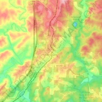
Nome: Mapa topográfico Ball Ground, altitude, relevo.
Local: Ball Ground, Cherokee County, Georgia, United States (34.31118 -84.41254 34.37075 -84.32178)
Altitude média: 331 m
Altitude mínima: 243 m
Altitude máxima: 414 m
Faça uma doação
Outros mapas topográficos
Clique em um mapa para visualizar sua topografia, sua altitude e seu relevo.