
Faça uma doação
Mapa topográfico Cape Cod
Clique no mapa para exibir a altitude.
Faça uma doação
Cape Cod
Cape Cod is a distinctive peninsula characterized by its low, gently sloping terrain that extends 65 miles into the Atlantic Ocean. The landscape consists primarily of sandy soils, dunes, and wetlands, with the highest point at Pine Hill reaching 306 feet. The region is dotted with freshwater ponds and bordered by expansive salt marshes and barrier beaches, which give the area its unique, shifting shoreline. The Cape’s varied topography is heavily influenced by glacial deposits and coastal processes, which shape its irregular and picturesque coastal contours.
Faça uma doação
Sobre este mapa
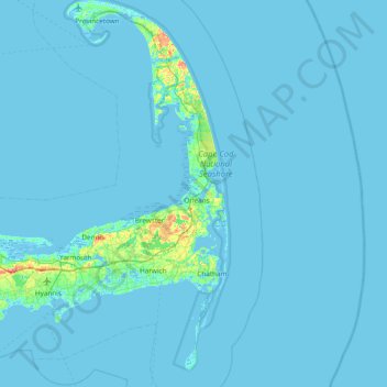
Nome: Mapa topográfico Cape Cod, altitude, relevo.
Local: Cape Cod, Barnstable County, Massachusetts, United States (41.51497 -70.68798 42.08253 -69.92900)
Altitude média: 2 m
Altitude mínima: -6 m
Altitude máxima: 56 m
Faça uma doação
Outros mapas topográficos
Clique em um mapa para visualizar sua topografia, sua altitude e seu relevo.
Faça uma doação
Faça uma doação
Opeechee Heights Beach
United States > Massachusetts > Barnstable County > Barnstable > Centerville
Altitude média: 14 m
Faça uma doação
West Barnstable
United States > Massachusetts > Barnstable County > West Barnstable
Altitude média: 15 m
Faça uma doação
Faça uma doação
Washburn Island
United States > Massachusetts > Barnstable County > Falmouth > Menauhant
Altitude média: 1 m
Faça uma doação
Faça uma doação
Faça uma doação
Bournedale
United States > Massachusetts > Barnstable County > Bourne > Bournedale
Altitude média: 29 m
Barnstable
United States > Massachusetts > Barnstable County > Barnstable > Barnstable
Altitude média: 10 m
Faça uma doação
Dennis Port
United States > Massachusetts > Barnstable County > Dennis > Dennis Port
Altitude média: 3 m
Faça uma doação