
Faça uma doação
Mapa topográfico Adam Pir
Clique no mapa para exibir a altitude.
Faça uma doação
Sobre este mapa
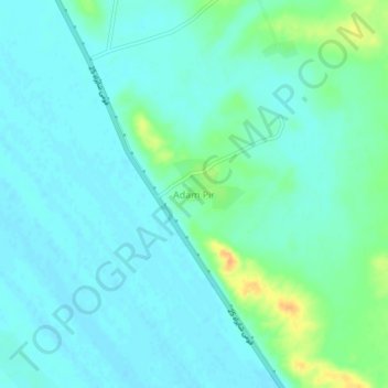
Nome: Mapa topográfico Adam Pir, altitude, relevo.
Local: Adam Pir, Lasbela District, Balochistan, Pakistan (25.28201 66.68177 25.32201 66.72177)
Altitude média: 13 m
Altitude mínima: 5 m
Altitude máxima: 40 m
Faça uma doação
Outros mapas topográficos
Clique em um mapa para visualizar sua topografia, sua altitude e seu relevo.
Ziarat District
Ziarat (Urdu: ضلع زیارت) is a district in the north of Balochistan province of Pakistan. Ziarat town (situated at an altitude of about 2,400 meters) is the headquarters of the district, the sub-division, and also of the tehsil. The highest peak of Khalifat Hills, at an altitude of 11,400 feet (3,500…
Altitude média: 1.837 m
Usta Muhammad Tehsil
Pakistan > Balochistan > Jafarabad District
Usta Mohammad is in the Kachhi plain basin, with an average altitude of about 55 meters. Annual rainfall is about 90mm, of which 60mm falls in winter (November–May). Winters are cold, and summers are dry and hot.
Altitude média: 53 m
Faça uma doação
Barkhan District
The landscape of Barkhan consists of plains, valleys and mountains varying in ground elevation ranging from 841 to 2,031 meters above Mean Sea Level (MSL). The district consists of one main valley, called Barkhan, and several smaller valleys, which are separated from the main valley by low ranges of hills…
Altitude média: 1.097 m
Faça uma doação
Qilla Abdullah District
Kila Abdullah district lies between 30 and 04' to 31–17' North Longitude in the foothills of the Shela Bagh Mountain range. It is bordered by Pishin District in the east, Quetta District in the South and by Afghanistan in the west. The geographical area of the district is 5,264 km2. It is composed of two…
Altitude média: 1.700 m
Panjgur District
Panjgur District covers an area of 16,891 square kilometres (6,522 sq mi) in western Balochistan, sharing an international border with Sistan and Baluchestan province of Iran to the west. This boundary, known as the Goldsmid Line, was formalised as the Perso-Baloch frontier in the nineteenth century and…
Altitude média: 857 m
Faça uma doação
Sherani District
Many wild plants in the area are used by local communities for traditional medicine, food, animal fodder, fencing, and household needs. At higher elevations, forested areas also include Pinus gerardiana (chilghoza pine), which is valued for its edible nuts and local importance.
Altitude média: 1.312 m
Faça uma doação
Faça uma doação
Faça uma doação
Faça uma doação