
Obrigado por apoiar este site ❤️
Faça uma doação
Faça uma doação
Mapa topográfico Le Hohwald
Clique no mapa para exibir a altitude.
Obrigado por apoiar este site ❤️
Faça uma doação
Faça uma doação
Le Hohwald
Le Hohwald is a hill village, with altitude above sea level in the commune ranging from 450 meters to nearly 1100 meters, positioned some fifty kilometres to the west-south-west of Strasbourg and some ten kilometres to the south-west of Mont Sainte-Odile. Its position in the lee of mountains protects it from north winds and from many of the frequent fogs and mists that are a feature of the climate elsewhere in Alsace, and supports claims of an unexpectedly benign climate all the year round.
Obrigado por apoiar este site ❤️
Faça uma doação
Faça uma doação
Sobre este mapa
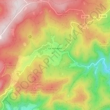
Nome: Mapa topográfico Le Hohwald, altitude, relevo.
Altitude média: 730 m
Altitude mínima: 358 m
Altitude máxima: 1.048 m
Obrigado por apoiar este site ❤️
Faça uma doação
Faça uma doação
Outros mapas topográficos
Clique em um mapa para visualizar sua topografia, sua altitude e seu relevo.