
Mapa topográfico Mount Bogong
Mapa interativo
Clique no mapa para exibir a altitude.
Sobre este mapa
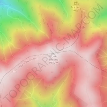
Nome: Mapa topográfico Mount Bogong, altitude, relevo.
Local: Mount Bogong, Shire of East Gippsland, Victoria, Australia (-36.73242 147.30578 -36.73232 147.30588)
Altitude média: 1.719 m
Altitude mínima: 1.109 m
Altitude máxima: 1.985 m
The Big River separates the massif of the mountain from the Bogong High Plains to the south. From the nearby town of Mount Beauty to its summit, Mount Bogong rises more than 1,600 metres (5,200 ft),[citation needed] thus making it one of the highest peaks in Australia not only in terms of its elevation above sea level, but also in terms of actual base-to-summit prominence.[citation needed]
Outros mapas topográficos
Clique em um mapa para visualizar sua topografia, sua altitude e seu relevo.
Melbourne Water Pipe Reserve
Australia > Victoria > Melbourne
Melbourne Water Pipe Reserve, Burwood East, Melbourne, City of Whitehorse, Victoria, Australia
Altitude média: 118 m
Langwarrin
Langwarrin, City of Frankston, Victoria, 3910, Australia
Altitude média: 71 m
Mount Fraser
Mount Fraser, Shire of Mitchell, Hume, Victoria, 3753, Australia
Altitude média: 309 m
Mount Strickland
Mount Strickland, Shire of Murrindindi, Hume, Victoria, Australia
Altitude média: 868 m
Lara District
Australia > Victoria > Geelong
Lara District, Shearers Lane, Lara, Geelong, City of Greater Geelong, Barwon South West, Victoria, 3212, Australia
Altitude média: 94 m
Croajingolong National Park
Croajingolong National Park, Lake Barracotta Link Track, Genoa, Shire of East Gippsland, Gippsland, Victoria, Australia
Altitude média: 50 m
Mount Feathertop
Mount Feathertop, Alpine Shire, Hume, Victoria, Australia
Altitude média: 1.533 m
Mount Dawson
Mount Dawson, Shire of East Gippsland, Gippsland, Victoria, Australia
Altitude média: 435 m
Badger Creek
Australia > Victoria > Healesville
Badger Creek, Healesville, Shire of Yarra Ranges, Victoria, Australia
Altitude média: 255 m
Basalt Lake
Australia > Victoria > Harkaway
Basalt Lake, Board Walk, Berwick, Harkaway, City of Casey, Victoria, 3806, Australia
Altitude média: 76 m
Wilsons Promontory National Park
Wilsons Promontory National Park, Vereker Outlook, Wilsons Promontory, Shire of South Gippsland, Gippsland, Victoria, Australia
Altitude média: 32 m