
Obrigado por apoiar este site ❤️
Faça uma doação
Faça uma doação
Mapa topográfico Farnborough
Clique no mapa para exibir a altitude.
Obrigado por apoiar este site ❤️
Faça uma doação
Faça uma doação
Farnborough
Farnborough is located in the northeastern corner of the county of Hampshire, near the border with Surrey. The town occupies a valley setting, with the main urban area situated between the River Blackwater to the east and higher ground to the west. The topography gradually rises from the valley floor, reaching a maximum elevation of around 90 metres (300 feet) above sea level on the fringes of the town.
Obrigado por apoiar este site ❤️
Faça uma doação
Faça uma doação
Sobre este mapa
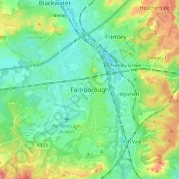
Nome: Mapa topográfico Farnborough, altitude, relevo.
Altitude média: 82 m
Altitude mínima: 57 m
Altitude máxima: 137 m
Obrigado por apoiar este site ❤️
Faça uma doação
Faça uma doação