
Mapa topográfico Aschersleben
Mapa interativo
Clique no mapa para exibir a altitude.
Sobre este mapa
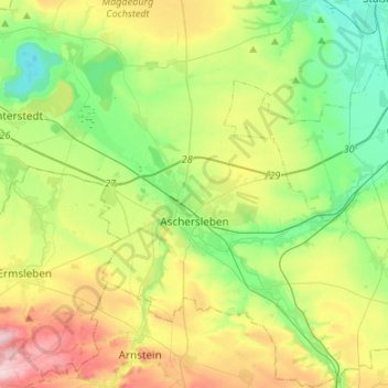
Nome: Mapa topográfico Aschersleben, altitude, relevo.
Local: Aschersleben, Salzlandkreis, Saxony-Anhalt, 06449, Germany (51.68462 11.37630 51.85060 11.63594)
Altitude média: 143 m
Altitude mínima: 54 m
Altitude máxima: 306 m
Outros mapas topográficos
Clique em um mapa para visualizar sua topografia, sua altitude e seu relevo.
Könnern
Germany > Saxony-Anhalt > Salzlandkreis
Könnern, Salzlandkreis, Saxony-Anhalt, Germany
Altitude média: 101 m
Lust
Germany > Saxony-Anhalt > Salzlandkreis > Staßfurt
Lust, Löderburg, Staßfurt, Salzlandkreis, Saxony-Anhalt, 39446, Germany
Altitude média: 71 m
Bernburg
Germany > Saxony-Anhalt > Salzlandkreis
Bernburg, Salzlandkreis, Saxony-Anhalt, 06406, Germany
Altitude média: 78 m
Cochstedt
Germany > Saxony-Anhalt > Salzlandkreis > Cochstedt
Cochstedt, Hecklingen, Salzlandkreis, Saxony-Anhalt, 39444, Germany
Altitude média: 135 m
Aschersleben
Germany > Saxony-Anhalt > Salzlandkreis > Aschersleben > Aschersleben
Aschersleben, Salzlandkreis, Saxony-Anhalt, 06449, Germany
Altitude média: 139 m
Hecklingen
Germany > Saxony-Anhalt > Salzlandkreis
Hecklingen, Salzlandkreis, Saxony-Anhalt, 39444, Germany
Altitude média: 96 m