
Faça uma doação
Mapa topográfico Fraser
Clique no mapa para exibir a altitude.
Faça uma doação
Fraser
Fraser is located in southeastern Grand County at 39°56′39″N 105°48′48″W / 39.94417°N 105.81333°W / 39.94417; -105.81333 (39.944158, -105.813355), at an elevation of 8,574 feet (2,613 m) above sea level. It is bordered to the south by the town of Winter Park and to the north by unincorporated Tabernash. U.S. Route 40 leads south and east across Berthoud Pass 71 miles (114 km) to Denver, and northwest 15 miles (24 km) to Granby, the largest town in Grand County.
Faça uma doação
Sobre este mapa
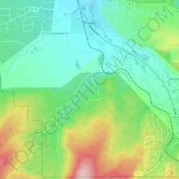
Nome: Mapa topográfico Fraser, altitude, relevo.
Local: Fraser, Grand County, Colorado, 80442, United States (39.90779 -105.82230 39.95298 -105.77621)
Altitude média: 2.696 m
Altitude mínima: 2.599 m
Altitude máxima: 2.888 m
Faça uma doação
Outros mapas topográficos
Clique em um mapa para visualizar sua topografia, sua altitude e seu relevo.
Winter Park
United States > Colorado > Grand County
Its elevation ranges from approximately 8,700 to 12,060 feet (2,650 to 3,680 m) above sea level, and is considered sub-alpine country. It is snow-covered for about six months a year. Although the town center is at about 9,000 feet (2,700 m) above sea level, Winter Park, using administrative boundaries as a…
Altitude média: 3.061 m
Faça uma doação
Faça uma doação