
Faça uma doação
Mapa topográfico Chino Hills
Clique no mapa para exibir a altitude.
Faça uma doação
Chino Hills
Due to its topography of rolling hills, Chino Hills was primarily rural prior to the mid-1970s; most land was utilized for equestrian purposes and for dairies, except for the multi-use purposes of the State of California, promoting jobs for the community through day labor from the Chino Institute for Men on Central Avenue. Rapid and extensive housing developments followed throughout the 1980s and early 1990s, only slowing down in recent years. Most neighborhoods are arranged in a village-type format with strategically placed shopping centers and parks designed to be within walking distance of nearby homes.
Faça uma doação
Sobre este mapa
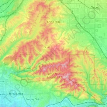
Nome: Mapa topográfico Chino Hills, altitude, relevo.
Altitude média: 255 m
Altitude mínima: 75 m
Altitude máxima: 533 m
Faça uma doação
Outros mapas topográficos
Clique em um mapa para visualizar sua topografia, sua altitude e seu relevo.
Running Springs
United States > California > San Bernardino County > Running Springs
Running Springs is a mountain community in the San Bernardino Mountains. It is an inholding in the San Bernardino National Forest. Situated at the junction of State Route 18 and State Route 330, it is a major gateway to the mountain communities of Lake Arrowhead, Arrowbear, Green Valley Lake, and Big Bear and…
Altitude média: 1.656 m
Cajon Pass
United States > California > San Bernardino County
Cajon Pass (/kəˈhoʊn/; Spanish: Puerto del Cajón or Paso del Cajón) is a mountain pass between the San Bernardino Mountains to the east and the San Gabriel Mountains to the west in Southern California. Created by the movements of the San Andreas Fault, it has an elevation of 3,777 ft (1,151 m). Located in…
Altitude média: 1.169 m
Faça uma doação
Faça uma doação
Cedar Glen
United States > California > San Bernardino County > Lake Arrowhead
Altitude média: 1.640 m
Meadowbrook Woods
United States > California > San Bernardino County > Lake Arrowhead
Altitude média: 1.560 m
Faça uma doação
Devil Canyon
United States > California > San Bernardino County > San Bernardino
Altitude média: 628 m
Faça uma doação
San Gorgonio Mountain
United States > California > San Bernardino County
Since it is the highest point in a region which is separated from higher peaks (e.g. in the Sierra Nevada) by relatively low terrain, San Gorgonio Mountain is one of the most topographically prominent peaks in the United States. It is ranked 7th among peaks in the 48 contiguous states and 18th overall.
Altitude média: 3.154 m
Faça uma doação
Arrowbear Lake
United States > California > San Bernardino County > Running Springs
Arrowbear Lake is an unincorporated community in San Bernardino County, California, United States. Its altitude is 6,086 feet (1,855 m) in the San Bernardino Mountains. It is located east of Running Springs along Highway 18 in the San Bernardino National Forest, a mountain community with a population of 736 in…
Altitude média: 1.928 m
Faça uma doação
Running Springs
United States > California > San Bernardino County
Running Springs is a mountain community in the San Bernardino Mountains. It is an inholding in the San Bernardino National Forest. Situated at the junction of State Route 18 and State Route 330, it is a major gateway to the mountain communities of Lake Arrowhead, Arrowbear, Green Valley Lake, and Big Bear and…
Altitude média: 1.673 m
Faça uma doação
Faça uma doação
Cucamonga Peak
United States > California > San Bernardino County
Cucamonga Peak is one of the highest peaks of the San Gabriel Mountains in San Bernardino County, California, with a summit elevation of 8,862 feet (2,701 m). It is within the Cucamonga Wilderness of the San Bernardino National Forest.
Altitude média: 2.240 m
Faça uma doação
Fort Irwin
United States > California > San Bernardino County
Fort Irwin National Training Center (Fort Irwin NTC) is a major training area for the United States military in the Mojave Desert in northern San Bernardino County, California. Fort Irwin is at an average elevation of 2,454 feet (748 m). It is located 37 miles (60 km) northeast of Barstow, in the Calico…
Altitude média: 774 m
Faça uma doação
Faça uma doação
Faça uma doação
Faça uma doação
Faça uma doação
Faça uma doação
Faça uma doação
Faça uma doação
Faça uma doação
Running Springs
United States > California > San Bernardino County
Running Springs is a mountain community in the San Bernardino Mountains. It is an inholding in the San Bernardino National Forest. Situated at the junction of State Route 18 and State Route 330, it is a major gateway to the mountain communities of Lake Arrowhead, Arrowbear, Green Valley Lake, and Big Bear and…
Altitude média: 1.673 m
Desert Knolls Manor
United States > California > San Bernardino County > Apple Valley
Altitude média: 928 m
Faça uma doação
Devil Canyon
United States > California > San Bernardino County > San Bernardino
Altitude média: 628 m
May Van Canyon Artesian Well
United States > California > San Bernardino County
Altitude média: 2.371 m
Faça uma doação
Faça uma doação
Faça uma doação
Devils Canyon Dike Number 1 17-002 Dam
United States > California > San Bernardino County > San Bernardino
Altitude média: 519 m
Faça uma doação
Running Springs
United States > California > San Bernardino County > Running Springs
Running Springs is a mountain community in the San Bernardino Mountains. It is an inholding in the San Bernardino National Forest. Situated at the junction of State Route 18 and State Route 330, it is a major gateway to the mountain communities of Lake Arrowhead, Arrowbear, Green Valley Lake, and Big Bear and…
Altitude média: 1.656 m
Faça uma doação
Cotners Corner
United States > California > San Bernardino County > Apple Valley
Altitude média: 915 m
Faça uma doação