
Faça uma doação
Mapa topográfico Huben
Clique no mapa para exibir a altitude.
Faça uma doação
Sobre este mapa
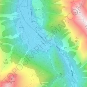
Nome: Mapa topográfico Huben, altitude, relevo.
Local: Huben, Längenfeld, Bezirk Imst, Tyrol, 6444, Austria (47.02030 10.95415 47.06030 10.99415)
Altitude média: 1.678 m
Altitude mínima: 1.170 m
Altitude máxima: 2.827 m
Faça uma doação
Outros mapas topográficos
Clique em um mapa para visualizar sua topografia, sua altitude e seu relevo.
Sölden
Austria > Tyrol > Bezirk Imst
The main village of Sölden is at an elevation of 1,368 metres (4,488 ft) above sea level, and the upper village of Hochsölden at 2,090 m (6,857 ft) has 5 four-star hotels. The highest peak is the Wildspitze, at 3,768 m (12,362 ft), the second highest mountain in Austria, after the Großglockner.
Altitude média: 2.483 m
Faça uma doação
Faça uma doação
Sölden
Austria > Tyrol > Bezirk Imst
The main village of Sölden is at an elevation of 1,368 metres (4,488 ft) above sea level, and the upper village of Hochsölden at 2,090 m (6,857 ft) has 5 four-star hotels. The highest peak is the Wildspitze, at 3,768 m (12,362 ft), the second highest mountain in Austria, after the Großglockner.
Altitude média: 2.483 m