
Faça uma doação
Mapa topográfico Big Pine
Clique no mapa para exibir a altitude.
Faça uma doação
Big Pine
Big Pine (formerly, Bigpine) is a census-designated place (CDP) in Inyo County, California, United States. Big Pine is located approximately 15 miles (24 km) south-southeast of Bishop, at an elevation of 3,989 feet (1,216 m). The population was 1,756 at the 2010 census, up from 1,350 at the 2000 census. The Big Pine Band of Owens Valley Paiute Shoshone Indians of the Big Pine Reservation operates their tribal headquarters from here.
Faça uma doação
Sobre este mapa
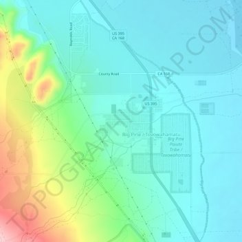
Nome: Mapa topográfico Big Pine, altitude, relevo.
Local: Big Pine, Inyo County, California, 92513, United States (37.14283 -118.31490 37.18673 -118.27680)
Altitude média: 1.228 m
Altitude mínima: 1.192 m
Altitude máxima: 1.391 m
Faça uma doação
Outros mapas topográficos
Clique em um mapa para visualizar sua topografia, sua altitude e seu relevo.