
Mapa topográfico Römerstadt
Mapa interativo
Clique no mapa para exibir a altitude.
Sobre este mapa
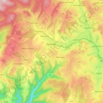
Nome: Mapa topográfico Römerstadt, altitude, relevo.
Altitude média: 643 m
Altitude mínima: 349 m
Altitude máxima: 924 m
Outros mapas topográficos
Clique em um mapa para visualizar sua topografia, sua altitude e seu relevo.
Zechitz
Tschechien > Mährisch-Schlesien > Römerstadt > Zechitz
Zechitz, Römerstadt, Bezirk Freudenthal, Mährisch-Schlesische Region, Mährisch-Schlesien, Tschechien
Altitude média: 647 m