
Faça uma doação
Mapa topográfico Isla Genovesa
Clique no mapa para exibir a altitude.
Faça uma doação
Isla Genovesa
Genovesa Island (Spanish: Isla Genovesa), also known as Tower Island, is a shield volcano in the Galápagos Islands in the eastern Pacific Ocean. The island occupies about 14 km2 (5 sq mi), and its maximum elevation is 64 m (210 ft). The horse-shoe shaped island has a volcanic caldera whose wall has collapsed, forming the Great Darwin Bay, surrounded by cliffs. The saltwater Lake Arcturus lies in the middle, and sediment within this crater lake is less than 6,000 years old. Although no historical eruptions are known from Genovesa, there are very young lava flows on the flanks of the volcano.
Faça uma doação
Sobre este mapa
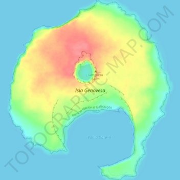
Nome: Mapa topográfico Isla Genovesa, altitude, relevo.
Altitude média: 21 m
Altitude mínima: 0 m
Altitude máxima: 76 m
Faça uma doação
Outros mapas topográficos
Clique em um mapa para visualizar sua topografia, sua altitude e seu relevo.
Parroquia Puerto Baquerizo Moreno
Ecuador > Galápagos > Cantón San Cristóbal
Puerto Baquerizo Moreno is the capital and administrative centre of Ecuador's Galápagos Province. It is located on the southwestern coast of San Cristóbal, and the town is also nicknamed Cristóbal by the local people, after the island. Its average elevation is 6 metres (20 ft). The central part of the town,…
Altitude média: 35 m
Faça uma doação
Punta Chacabuco
Ecuador > Galápagos > Cantón San Cristóbal > Parroquia Puerto Baquerizo Moreno
Altitude média: 12 m