
Mapa topográfico Negal
Clique no mapa para exibir a altitude.
Sobre este mapa
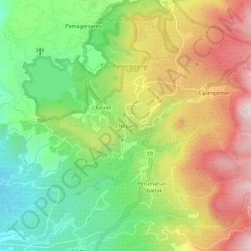
Nome: Mapa topográfico Negal, altitude, relevo.
Altitude média: 1.710 m
Altitude mínima: 1.415 m
Altitude máxima: 2.074 m
Outros mapas topográficos
Clique em um mapa para visualizar sua topografia, sua altitude e seu relevo.
Patenggang Lake
Indonesia > West Java > Kabupaten Bandung > Rancabali > Bauan
Patenggang Lake (Indonesian: Situ Patenggang) is a lake located in the area of natural tourist attractions in the southern Bandung City, West Java, Indonesia, to be exact it is in Ciwidey village. Located at an altitude of 1600 meters above sea level, this lake has a very exotic landscape. The lake is spread…
Altitude média: 1.715 m