
Mapa topográfico Garden District
Mapa interativo
Clique no mapa para exibir a altitude.
Sobre este mapa
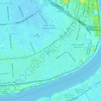
Nome: Mapa topográfico Garden District, altitude, relevo.
Altitude média: 4 m
Altitude mínima: -1 m
Altitude máxima: 26 m
The Garden District is located at 29°55′40″N 90°05′05″W / 29.92778°N 90.08472°W / 29.92778; -90.08472 and has an elevation of 3 feet (0.9 m). According to the United States Census Bureau, the district has a total area of 0.21 square miles (0.5 km2). 0.21 square miles (0.5 km2) of which is land and 0.00 square miles (0.0 km2) (0.0%) of which is water.