
Mapa topográfico Harrogate
Clique no mapa para exibir a altitude.
Harrogate
Harrogate is situated on the edge of the Yorkshire Dales, with the Vale of York to the east and the upland Yorkshire Dales to the west and north-west. It has a dry and mild climate, typical of places in the rain shadow of the Pennines. It is on the A59 from Skipton to York. At an altitude of between 100 and 200 metres (330 and 660 ft), Harrogate is higher than many English settlements. It has an average minimum temperature in January of slightly below 0 °C (32 °F) and an average maximum in July and August of 20 °C (68 °F).
Sobre este mapa
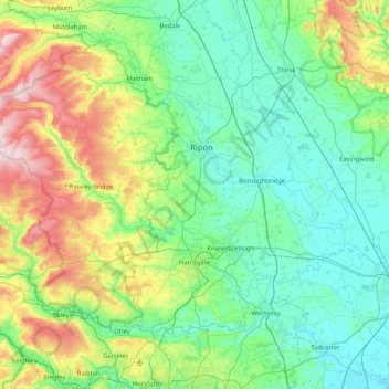
Nome: Mapa topográfico Harrogate, altitude, relevo.
Local: Harrogate, North Yorkshire, England, United Kingdom (53.89141 -2.00450 54.26160 -1.17500)
Altitude média: 131 m
Altitude mínima: 4 m
Altitude máxima: 568 m
Outros mapas topográficos
Clique em um mapa para visualizar sua topografia, sua altitude e seu relevo.
Swinithwaite
United Kingdom > England > North Yorkshire > Richmondshire > West Witton > Swinithwaite
Altitude média: 205 m
Bolton Castle
United Kingdom > England > North Yorkshire > Redmire > Castle Bolton
Altitude média: 250 m
Thimbleby & Osmotherly Show field
United Kingdom > England > North Yorkshire > Thimbleby
Altitude média: 152 m
Beckwithshaw
United Kingdom > England > North Yorkshire > Harrogate > Beckwithshaw
Altitude média: 161 m
Arkle Town
United Kingdom > England > North Yorkshire > Richmondshire > Arkle Town
Altitude média: 367 m