
Mapa topográfico Regina
Mapa interativo
Clique no mapa para exibir a altitude.
Regina
Unlike other planned cities in the Canadian West, on its treeless flat plain Regina has few topographical features other than the small spring run-off, Wascana Creek. Early planners took advantage of such opportunity by damming the creek to create a decorative lake to the south of the central business district with a dam a block and a half west of the later elaborate 260 m (850 ft) long Albert Street Bridge across the new lake. Regina's importance was further secured when the new province of Saskatchewan designated the city its capital in 1906. Wascana Centre, created around the focal point of Wascana Lake, remains one of Regina's attractions and contains the Provincial Legislative Building, both campuses of the University of Regina, First Nations University of Canada, the Royal Saskatchewan Museum, the Regina Conservatory (in the original Regina College buildings), the Saskatchewan Science Centre, the MacKenzie Art Gallery and the Saskatchewan Centre of the Arts.
Sobre este mapa
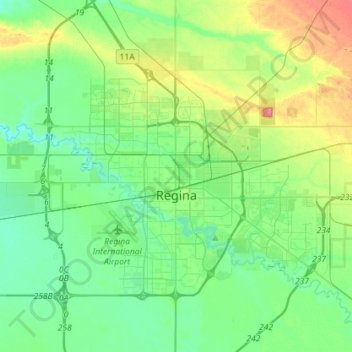
Nome: Mapa topográfico Regina, altitude, relevo.
Local: Regina, Saskatchewan, Canada (50.39641 -104.77811 50.52073 -104.49207)
Altitude média: 582 m
Altitude mínima: 562 m
Altitude máxima: 633 m
Outros mapas topográficos
Clique em um mapa para visualizar sua topografia, sua altitude e seu relevo.
Saskatoon
Canada > Saskatchewan > Saskatoon
Saskatoon lies on a long belt of rich, potassic chernozem in middle-southern Saskatchewan and is found in the aspen parkland biome. The lack of surrounding mountainous topography gives the city a relatively flat grid, though the city does sprawl over a few hills and into a few valleys. The lowest point in the…
Altitude média: 510 m