
Mapa topográfico Howe
Mapa interativo
Clique no mapa para exibir a altitude.
Howe
Howe's elevation of 860 feet (260 m) is the highest point along US 75 between the Red River and the Gulf of Mexico.
Sobre este mapa
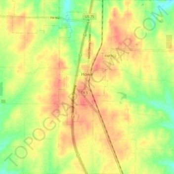
Nome: Mapa topográfico Howe, altitude, relevo.
Local: Howe, Grayson County, Texas, 75459, United States (33.46537 -96.65025 33.53849 -96.59389)
Altitude média: 248 m
Altitude mínima: 218 m
Altitude máxima: 269 m
Outros mapas topográficos
Clique em um mapa para visualizar sua topografia, sua altitude e seu relevo.
Howe
United States > Texas > Grayson County
Howe's elevation of 860 feet (260 m) is the highest point along US 75 between the Red River and the Gulf of Mexico.
Altitude média: 248 m