
Mapa topográfico Table Hill
Clique no mapa para exibir a altitude.
Table Hill
Table Hill is situated in the range of Malvern Hills that runs about 13 kilometres (8 mi) north-south along the Herefordshire-Worcestershire border. It lies between North Hill and Sugarloaf Hill and has an elevation of 373 metres (1,224 ft).
Sobre este mapa
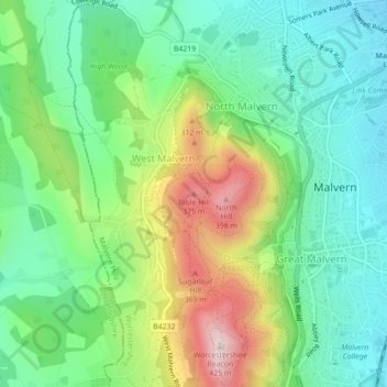
Nome: Mapa topográfico Table Hill, altitude, relevo.
Altitude média: 188 m
Altitude mínima: 68 m
Altitude máxima: 423 m
Outros mapas topográficos
Clique em um mapa para visualizar sua topografia, sua altitude e seu relevo.
Broadheath
United Kingdom > England > Worcestershire > Malvern Hills > Lower Broadheath
Altitude média: 44 m
Knighton on Teme
United Kingdom > England > Worcestershire > Malvern Hills > Knighton on Teme
Altitude média: 82 m
West Malvern
United Kingdom > England > Worcestershire > Malvern Hills
West Malvern is a village and a civil parish on the west side of the north part of the Malvern Hills, on the western edge of Worcestershire, England. It has become effectively a suburb of Malvern and part of an urban area often called The Malverns, locally administered by Malvern Hills District Council and its…
Altitude média: 198 m