
Faça uma doação
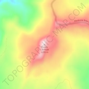
Mapa topográfico Sleepy Cat Peak
Clique no mapa para exibir a altitude.
Faça uma doação
Sleepy Cat Peak
Sleepy Cat Peak, elevation 10,853 ft (3,308 m), is a summit in the Flat Tops of northwest Colorado. The mountain is east of Meeker in the White River National Forest of Rio Blanco County.
Faça uma doação
Sobre este mapa
Nome: Mapa topográfico Sleepy Cat Peak, altitude, relevo.
Altitude média: 3.090 m
Altitude mínima: 2.861 m
Altitude máxima: 3.280 m
Faça uma doação
Outros mapas topográficos
Clique em um mapa para visualizar sua topografia, sua altitude e seu relevo.
Meeker
United States > Colorado > Rio Blanco County
According to the United States Census Bureau, the town has a total area of 2.9 square miles (7.5 km2), all of it land. The town is situated on the White River at an elevation of 6,250 feet above sea level.
Altitude média: 2.016 m
Meeker
United States > Colorado > Rio Blanco County
According to the United States Census Bureau, the town has a total area of 2.9 square miles (7.5 km2), all of it land. The town is situated on the White River at an elevation of 6,250 feet above sea level.
Altitude média: 2.016 m
Faça uma doação