
Obrigado por apoiar este site ❤️
Faça uma doação
Faça uma doação
Mapa topográfico Wendover
Clique no mapa para exibir a altitude.
Obrigado por apoiar este site ❤️
Faça uma doação
Faça uma doação
Sobre este mapa
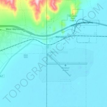
Nome: Mapa topográfico Wendover, altitude, relevo.
Local: Wendover, Tooele County, Utah, United States (40.68974 -114.04381 40.76227 -113.99902)
Altitude média: 1.325 m
Altitude mínima: 1.279 m
Altitude máxima: 1.770 m
Obrigado por apoiar este site ❤️
Faça uma doação
Faça uma doação
Outros mapas topográficos
Clique em um mapa para visualizar sua topografia, sua altitude e seu relevo.
Deseret Peak
United States > Utah > Tooele County
Deseret Peak is the highest peak in the Stansbury Mountains with an elevation of 11,035 ft. It is located in the Deseret Peak Wilderness area west of Grantsville, Utah and east of Skull Valley Indian Reservation. It is the fourth most topographically prominent peak in the state of Utah. The site is a popular…
Altitude média: 2.910 m
Obrigado por apoiar este site ❤️
Faça uma doação
Faça uma doação