
Mapa topográfico Neureuth
Mapa interativo
Clique no mapa para exibir a altitude.
Sobre este mapa
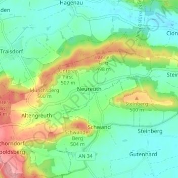
Nome: Mapa topográfico Neureuth, altitude, relevo.
Altitude média: 459 m
Altitude mínima: 426 m
Altitude máxima: 528 m
Outros mapas topográficos
Clique em um mapa para visualizar sua topografia, sua altitude e seu relevo.
Schlosspark Schillingsfürst
Deutschland > Bayern > Landkreis Ansbach > Schillingsfürst > Stilzendorf
Schlosspark Schillingsfürst, Schafhofsteige, Stilzendorf, Schillingsfürst, Schillingsfürst (VGem), Landkreis Ansbach, Bayern, 91583, Deutschland
Altitude média: 489 m