
Mapa topográfico Euboea
Mapa interativo
Clique no mapa para exibir a altitude.
Sobre este mapa
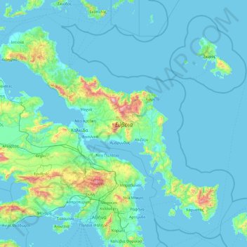
Nome: Mapa topográfico Euboea, altitude, relevo.
Altitude média: 113 m
Altitude mínima: -1 m
Altitude máxima: 1.672 m
Outros mapas topográficos
Clique em um mapa para visualizar sua topografia, sua altitude e seu relevo.
Mitikas
Greece > Thessaly - Central Greece
Mitikas, Skiathos Municipality, Regional Unit of Sporades, Region of Thessaly, Thessaly - Central Greece, 37002, Greece
Altitude média: 261 m
Pindus
Greece > Thessaly - Central Greece
Pindus, Δήμος Αργιθέας, Karditsa Regional Unit, Region of Thessaly, Thessaly - Central Greece, Greece
Altitude média: 1.510 m