
Faça uma doação
Mapa topográfico Cairnbaan
Clique no mapa para exibir a altitude.
Faça uma doação
Sobre este mapa
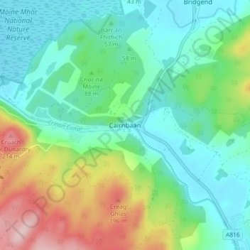
Nome: Mapa topográfico Cairnbaan, altitude, relevo.
Local: Cairnbaan, Argyll and Bute, Scotland, PA31 8BA, United Kingdom (56.04110 -5.49258 56.08110 -5.45258)
Altitude média: 68 m
Altitude mínima: -1 m
Altitude máxima: 234 m
Faça uma doação
Outros mapas topográficos
Clique em um mapa para visualizar sua topografia, sua altitude e seu relevo.
Faça uma doação
Faça uma doação
Faça uma doação
Faça uma doação
Castle Sween
United Kingdom > Scotland > Argyll and Bute > Achnamara > Kilmichael of Inverlussa
Altitude média: 55 m
Faça uma doação
Faça uma doação
Faça uma doação
Lismore
United Kingdom > Scotland > Argyll and Bute > Achnacroish
The island of Lismore lies in Loch Linnhe, north east of Mull, in the Argyll and Bute council area. It is 15 kilometres (9.3 mi) long and about 2 kilometres (1.2 mi) wide and oriented from SW to NE, roughly parallel to the Great Glen Fault. To the east is an arm of Loch Linnhe known as the Lynn of Lorn.…
Altitude média: 16 m
Faça uma doação
Faça uma doação
Faça uma doação
Faça uma doação
Faça uma doação
Loch Sunart to the Sound of Jura Marine Protected Area
United Kingdom > Scotland > Argyll and Bute
Altitude média: 135 m
Faça uma doação
Gigha
United Kingdom > Scotland > Argyll and Bute > Ardminish
Gigha lies 5 kilometres (3 mi) off the coast of Kintyre and is 9.5 km (6 mi) long in a roughly north-south direction and a maximum of 2.5 km (1 1⁄2 mi) wide. The total area is 1,395 hectares (3,450 acres) and the highest elevation of Creag Bhàn reaches only 100 m (330 ft). The rocky central spine is…
Altitude média: 3 m
Faça uma doação
Faça uma doação
Faça uma doação
Faça uma doação
Faça uma doação
Faça uma doação
Faça uma doação