
Obrigado por apoiar este site ❤️
Faça uma doação
Faça uma doação
Mapa topográfico Córdoba
Clique no mapa para exibir a altitude.
Obrigado por apoiar este site ❤️
Faça uma doação
Faça uma doação
Córdoba
Córdoba is located in the center of the state of Veracruz, at 18º51'30" north latitude and 96º55'51" west longitude. It lies between the hills of Matlaquiahitl and Tepixtepec, at an elevation of 817 meters (2,680 feet) above mean sea level.
Obrigado por apoiar este site ❤️
Faça uma doação
Faça uma doação
Sobre este mapa
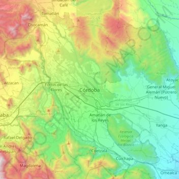
Nome: Mapa topográfico Córdoba, altitude, relevo.
Local: Córdoba, Veracruz, 94500, Mexico (18.73447 -97.09529 19.05447 -96.77529)
Altitude média: 1.030 m
Altitude mínima: 372 m
Altitude máxima: 2.532 m
Obrigado por apoiar este site ❤️
Faça uma doação
Faça uma doação