
Mapa topográfico Passo dello Stelvio
Mapa interativo
Clique no mapa para exibir a altitude.
Sobre este mapa
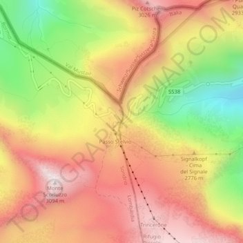
Nome: Mapa topográfico Passo dello Stelvio, altitude, relevo.
Altitude média: 2.724 m
Altitude mínima: 2.261 m
Altitude máxima: 3.075 m
The Stelvio Pass (Italian: Passo dello Stelvio [passo ˈdello ˈstɛlvjo], Giogo dello Stelvio [dʒɔgo ˈdello ˈstɛlvjo]; German: Stilfser Joch; [ˈʃtɪlfsɐ jɔx]) is a mountain pass in northern Italy bordering Switzerland at an elevation of 2,757 m (9,045 ft) above sea level. It is the highest paved mountain pass in the Eastern Alps, and the second highest in the Alps, 7 m (23 ft) below France's Col de l'Iseran (2,764 m (9,068 ft)).
Outros mapas topográficos
Clique em um mapa para visualizar sua topografia, sua altitude e seu relevo.
Neuwies - Pratonuovo
Italy > Trentino-Alto Adige/Südtirol > South Tyrol > Stilfs - Stelvio > Trafoi
Neuwies - Pratonuovo, Trafoi, Stilfs - Stelvio, Vinschgau - Val Venosta, South Tyrol, Trentino-Alto Adige/Südtirol, 39029, Italy
Altitude média: 2.088 m
Ortler - Ortles
Italy > Trentino-Alto Adige/Südtirol > South Tyrol > Stilfs - Stelvio
Ortler - Ortles, Stilfs - Stelvio, Vinschgau - Val Venosta, South Tyrol, Trentino-Alto Adige/Südtirol, Italy
Altitude média: 3.177 m