
Mapa topográfico Hogs Back
Mapa interativo
Clique no mapa para exibir a altitude.
Sobre este mapa
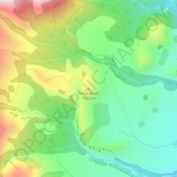
Nome: Mapa topográfico Hogs Back, altitude, relevo.
Local: Hogs Back, Selwyn District, Canterbury, 7580, New Zealand (-43.18273 171.68741 -43.18263 171.68751)
Altitude média: 925 m
Altitude mínima: 732 m
Altitude máxima: 1.249 m
Outros mapas topográficos
Clique em um mapa para visualizar sua topografia, sua altitude e seu relevo.
Hydra Island
New Zealand > Canterbury > Selwyn District
Hydra Island, Selwyn District, Canterbury, New Zealand
Altitude média: 474 m
Golgotha
New Zealand > Canterbury > Selwyn District
Golgotha, Selwyn District, Canterbury, New Zealand
Altitude média: 410 m
West Melton
New Zealand > Canterbury > Selwyn District
West Melton, Selwyn District, Canterbury, 7618, New Zealand
Altitude média: 88 m
Mt Barker
New Zealand > Canterbury > Selwyn District
Mt Barker, Selwyn District, Canterbury, New Zealand
Altitude média: 617 m
Prebbleton
New Zealand > Canterbury > Selwyn District
Prebbleton, Selwyn District, Canterbury, 7604, New Zealand
Altitude média: 25 m
Arthur's Pass
New Zealand > Canterbury > Selwyn District
Arthur's Pass, Selwyn District, Canterbury, 7875, New Zealand
Altitude média: 1.204 m
Rolleston
New Zealand > Canterbury > Selwyn District
Rolleston, Selwyn District, Canterbury, 7614, New Zealand
Altitude média: 54 m