Geolocalizar

Mapa topográfico Pfarrkirchen

Mapa interativo

Clique no mapa para exibir a altitude.

Sobre este mapa

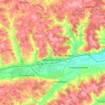
Nome: Mapa topográfico Pfarrkirchen, altitude, relevo.

Local: Pfarrkirchen, Landkreis Rottal-Inn, Bavaria, 84347, Germany (48.39223 12.89848 48.48486 13.01114)

Altitude média: 429 m

Altitude mínima: 356 m

Altitude máxima: 483 m

Outros mapas topográficos

Clique em um mapa para visualizar sua topografia, sua altitude e seu relevo.

Walking

Germany > Bavaria > Landkreis Rottal-Inn > Wittibreut

Walking, Wittibreut, Landkreis Rottal-Inn, Bavaria, 84384, Germany

Altitude média: 504 m

Putting

Germany > Bavaria > Landkreis Rottal-Inn > Wurmannsquick

Putting, Wurmannsquick, Landkreis Rottal-Inn, Bavaria, 84329, Germany

Altitude média: 464 m

Hintergrindering

Germany > Bavaria > Landkreis Rottal-Inn > Seemannshausen

Hintergrindering, Seemannshausen, Gangkofen, Landkreis Rottal-Inn, Bavaria, 84140, Germany

Altitude média: 468 m

Gindering

Germany > Bavaria > Landkreis Rottal-Inn > Gangkofen

Gindering, Gangkofen, Landkreis Rottal-Inn, Bavaria, 84140, Germany

Altitude média: 465 m

Gangkofen

Germany > Bavaria > Landkreis Rottal-Inn

Gangkofen, Landkreis Rottal-Inn, Bavaria, 84140, Germany

Altitude média: 471 m

Simbach

Germany > Bavaria > Landkreis Rottal-Inn

Simbach, Landkreis Rottal-Inn, Bavaria, 84359, Germany

Altitude média: 425 m