
Mapa topográfico Dellhofen
Mapa interativo
Clique no mapa para exibir a altitude.
Sobre este mapa
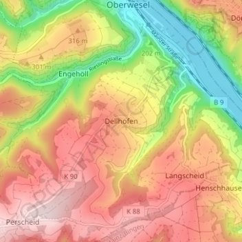
Nome: Mapa topográfico Dellhofen, altitude, relevo.
Altitude média: 273 m
Altitude mínima: 71 m
Altitude máxima: 441 m
Das Rheinhöhendorf Dellhofen ist ein Stadtteil und ein Ortsbezirk der Stadt Oberwesel im Rhein-Hunsrück-Kreis in Rheinland-Pfalz.
Outros mapas topográficos
Clique em um mapa para visualizar sua topografia, sua altitude e seu relevo.
Langscheid
Deutschland > Rheinland-Pfalz > Rhein-Hunsrück-Kreis > Oberwesel
Langscheid, Oberwesel, Hunsrück-Mittelrhein, Rhein-Hunsrück-Kreis, Rheinland-Pfalz, 55422, Deutschland
Altitude média: 263 m