
Faça uma doação
Mapa topográfico Malerkotla
Clique no mapa para exibir a altitude.
Faça uma doação
Sobre este mapa
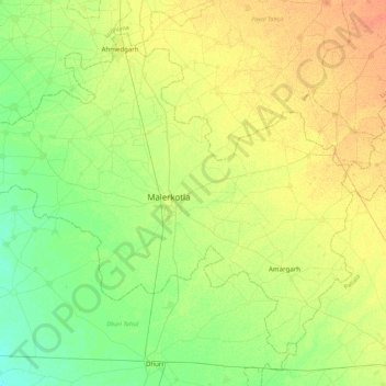
Nome: Mapa topográfico Malerkotla, altitude, relevo.
Local: Malerkotla, Punjab, India (30.38152 75.65275 30.69269 76.08850)
Altitude média: 248 m
Altitude mínima: 234 m
Altitude máxima: 265 m
Faça uma doação
Outros mapas topográficos
Clique em um mapa para visualizar sua topografia, sua altitude e seu relevo.
Faça uma doação
Mukerian
India > Punjab > Mukerian Tahsil
Mukerian is located at 31°57′N 75°37′E / 31.95°N 75.62°E / 31.95; 75.62. It has an average elevation of 245 metres (804 ft).
Altitude média: 258 m
Faça uma doação
Hoshiarpur
India > Punjab > Hoshiarpur Tahsil
Hoshiarpur has an average elevation of 296 metres (971 ft). Hoshiarpur district is located in the north-east part of the Indian state of Punjab. It falls in the Jalandhar Revenue Division and is situated in the Bist Doab portion of the Doaba region. Hoshiarpur shares a boundary with Kangra district, and Una…
Altitude média: 327 m
Faça uma doação
Faça uma doação
Faça uma doação
Faça uma doação
Faça uma doação
Bathinda
India > Punjab > Bathinda Tahsil
Bathinda is in the northwestern region of India and is a part of the Indo-Gangetic alluvial plains. The exact cartographic co-ordinates of Bathinda are 30°12′N 74°57′E / 30.20°N 74.95°E / 30.20; 74.95. It has an average elevation of 201 metres (660 ft).
Altitude média: 208 m
Faça uma doação
Khamanon
India > Punjab > Khamanon Tahsil
Khamanon is located at 30°49′N 76°21′E / 30.82°N 76.35°E / 30.82; 76.35. It has an average elevation of 254 metres (833 feet).
Altitude média: 274 m
Faça uma doação
Faça uma doação
Faça uma doação
Rajpura
India > Punjab > Rajpura Tahsil
Rajpura is located at 30°29′N 76°36′E / 30.48°N 76.6°E / 30.48; 76.6. It has an average elevation of 259 metres (849 feet). Rajpura is situated nearly 38 km south west of Chandigarh, the capital city of Punjab. Besides being an important industrial town of Punjab, it also has historical importance.
Altitude média: 270 m
Faça uma doação
Patiala
India > Punjab > Patiala Tahsil > Patiala
Patiala is located at 30°19′N 76°24′E / 30.32°N 76.40°E / 30.32; 76.40. It has an average elevation of 250 metres (820 feet). During the short existence of PEPSU, Patiala served as its capital city.
Altitude média: 255 m
Faça uma doação
Kartarpur
India > Punjab > Jalandhar II Tahsil > Kartarpur
Kartarpur is located at 31°26′N 75°30′E / 31.44°N 75.5°E / 31.44; 75.5. It has an average elevation of 228 metres (748 feet). It is situated at a distance of 15 km from Jalandhar towards Amritsar on G.T. Road (National Highway 1).
Altitude média: 236 m
Faça uma doação
Faça uma doação
Faça uma doação